| Feature | Detail |
|---|---|
| Location | South Pacific Ocean, approx. 19°S 169°W |
| Land area | 261 km² |
| Coastline length | 64 km |
| Highest point | ~68 m above sea level |
| Capital | Alofi (west coast) |
| Capital population | ~600 (2024 estimate) |
| Island type | Raised coral atoll (makatea) |
| Number of villages | 14 |
| Resident population | ~1,500 (2024 estimate) |
| EEZ area | ~317,500 km² |
| UNESCO Biosphere Reserve | Entire island and surrounding ocean (designated 2006) |
| Time zone | UTC−11 (Niue Time, NUT) |
| Currency | New Zealand dollar (NZD) |
Niue is a raised coral island in the South Pacific — not a volcanic island, not a low-lying atoll, but a limestone plateau lifted above the ocean by tectonic forces over millions of years. That geological fact shapes everything: the terrain, the coastline, the water supply, the soil, and the biodiversity. Understanding Niue's geography starts with understanding what makatea limestone does to an island.
Where Niue Is Located
Niue sits at approximately 19°S, 169°W in the South Pacific Ocean. It is geographically isolated even by Pacific standards.
| Nearest location | Approximate distance |
|---|---|
| Tonga | 480 km west |
| Samoa | 930 km northwest |
| Cook Islands (Rarotonga) | 930 km east |
| Fiji | 1,500 km west-northwest |
| Auckland, New Zealand | 2,400 km southwest |
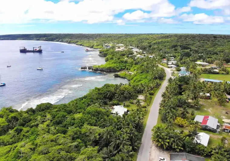
The island is roughly oval in shape. It has no natural harbour — the limestone coastline drops directly into the ocean, and the only access point for ships is a small wharf at Alofi. Cargo and passenger vessels anchor offshore and transfer by smaller boat. This isolation has shaped Niuean history, culture, and the sustained pace of outmigration to New Zealand since the 1970s.
Geology: What Makatea Means in Practice
Niue is one of the largest uplifted coral atolls in the world. The island began as a coral reef growing on a volcanic seamount. Over millions of years, tectonic uplift raised the reef above sea level. The result is a limestone plateau — makatea — with cliffs on all sides and a relatively flat interior.
The limestone is porous. Rainwater drains straight through the rock rather than forming rivers or streams. Niue has no rivers and no permanent surface water. Fresh water comes from rainwater collection and underground aquifers accessed through wells. Annual rainfall averages around 2,000 mm, so this is not a shortage — but the island's water infrastructure is entirely dependent on collection and storage, with no rivers to draw from.
The porous rock also produces thin, nutrient-poor soil. Agriculture is limited to taro, yams, coconuts, and some root vegetables. The limestone leaches nutrients quickly, which rules out large-scale farming.
Terrain and Elevation
The island's interior is a raised limestone plateau sitting at roughly 60–68 metres above sea level. The highest point is approximately 68 m — low by any standard, but significant for a coral island. The plateau is relatively flat, covered by tropical forest in the interior and village settlements near the coast.
The coastline is the dramatic part. Limestone cliffs drop to the ocean, broken by chasms, sea caves, natural arches, and rock pools. There are no sandy beaches in the conventional sense — swimming and ocean access happen through chasms and rock pools cut into the limestone.
| Terrain feature | Description |
|---|---|
| Matapa Chasm | Deep limestone chasm; historically reserved as a bathing place for Niuean royalty |
| Togo Chasm | Inland chasm with dense tropical vegetation; accessible by a narrow trail |
| Talava Arches | Natural limestone arches on the northwest coast |
| Avaiki Cave | Sea cave on the west coast, accessible at low tide |
| Limu pools | Natural rock pools along the coastline used for swimming |
| Huvalu Forest | Interior tropical forest covering approximately 54% of the island (~5,400 ha) |
Climate
Niue has a tropical climate with two seasons. The wet season runs from November to April; the dry season from May to October. Niue Language Week (19–25 October 2026) falls at the transition point — the end of the dry season, before the rains return.
| Climate metric | Detail |
|---|---|
| Average annual rainfall | ~2,000 mm |
| Temperature range | 20°C – 30°C year-round |
| Wet season | November – April |
| Dry season | May – October |
| Cyclone risk | Within the South Pacific cyclone belt |
Cyclone Heta in January 2004 was the most destructive storm in Niue's recorded history. It killed two people, destroyed most of Alofi, and caused damage estimated at NZD 100 million — roughly equivalent to the island's entire GDP at the time. The rebuilt Alofi is more cyclone-resistant than the pre-2004 town, but the island remains within the South Pacific cyclone belt and cyclone preparedness is a permanent feature of island life.
The Capital: Alofi
Alofi sits on the west coast and functions as the island's administrative, commercial, and transport hub. With a population of approximately 600 people, it is one of the smallest national capitals in the world by population — smaller than many New Zealand suburbs.
The government buildings, hospital, main market, and the island's only wharf are all in or near Alofi. The town was largely rebuilt after Cyclone Heta in 2004. The west coast location is deliberate: the prevailing winds and swells come from the east and southeast, making the west coast the calmer side for the wharf and for the limu pools that are a feature of Niuean coastal life.
Villages and Administrative Districts
Niue has 14 villages. The island is divided into two administrative districts: Niue Foou (new Niue, the northern district) and Niue Hahake (east Niue, the eastern district).
| Village | Location |
|---|---|
| Alofi | West coast (capital) |
| Alofi North | North |
| Tuapa | North |
| Hikutavake | North |
| Makefu | North |
| Namukulu | North |
| Mutalau | North |
| Lakepa | East |
| Toi | East |
| Liku | East |
| Hakupu | East |
| Vaiea | South |
| Avatele | South |
| Tamakautoga | South |
Most villages have populations of 50–200 people. The depopulation that reduced the island's total resident count from roughly 5,000 in the 1960s to around 1,500 today has left some villages with very few permanent residents. Several village sites are maintained by families who live in New Zealand and return periodically.
The Exclusive Economic Zone
Niue's land area is 261 km². Its Exclusive Economic Zone (EEZ) covers approximately 317,500 km² of ocean — more than 1,200 times the land area. This ratio is common among Pacific island nations, but the scale is still striking.
The EEZ gives Niue sovereign rights over fisheries, seabed resources, and marine research within that area. In practice, Niue's government has limited capacity to patrol or manage the full EEZ. Fisheries agreements with other nations provide some revenue, and the UNESCO Biosphere Reserve designation (see below) provides an international framework for marine conservation within the zone.
Marine Environment and Biodiversity
The waters around Niue are among the clearest in the Pacific. Visibility can reach 70 metres in some areas. The reason is geological: Niue has no rivers, so there is no sediment runoff into the ocean. The limestone coastline filters rather than deposits.
In 2006, Niue became the first country in the world to be declared a UNESCO Biosphere Reserve in its entirety — covering both the land and the surrounding ocean. The designation recognises the island's intact ecosystems and the Niuean government's conservation commitments.
| Species | Niuean name | Notes |
|---|---|---|
| Coconut crab | Uga | One of the largest populations in the Pacific; a cultural symbol |
| Humpback whale | Tafola | Migrates through Niuean waters July–October |
| Flying fox | Peka | Fruit bat; important for forest pollination and seed dispersal |
| Sea snake | — | Present in coastal waters; non-aggressive |
| Spinner dolphin | — | Common in offshore waters |
The coconut crab (uga, Birgus latro) is the world's largest land invertebrate — reaching up to 4 kg and a leg span of 1 metre. Niue is one of the few Pacific islands where the species remains abundant. On many islands it has been hunted to near-extinction. The uga's abundance on Niue reflects the island's low population density and cultural practices around sustainable harvesting. The word uga and its cultural weight are well known to Niueans in New Zealand — it functions as an informal symbol of Niuean identity in the diaspora.
Humpback whales (Megaptera novaeangliae) use Niuean waters as a breeding and calving ground between July and October. The timing overlaps with the dry season and with Niue Language Week in October. Whale watching from the limestone cliffs is possible without a boat — the water clarity and the cliff height make surface sightings common.
Huvalu Forest Conservation Area
The Huvalu Forest Conservation Area covers approximately 5,400 hectares — roughly 54% of Niue's total land area. It is the island's primary conservation zone, protecting the interior tropical forest that sits on the limestone plateau.
The forest contains native tree species, flying foxes, and several endemic bird species. It is managed by the Niue government's Environment Department. Walking tracks provide access, but the terrain requires care: porous limestone has sharp edges and hidden holes that are not obvious from the surface.
Niue's Relationship with the Ocean
Niue's geography creates an unusual relationship with the sea. The island has no beaches, no rivers, no harbour. The ocean is simultaneously the island's isolation and its connection to the world.
The limestone coastline means ocean access is through specific points — chasms, pools, and gaps in the cliff. These access points are known to local communities and have names. Matapa Chasm was historically reserved for Niuean royalty. The limu pools along the west coast are used for swimming and are a feature of daily life for residents.
The island's position in the South Pacific also places it within the migration routes of humpback whales, spinner dolphins, and various seabird species. The surrounding ocean is not just a geographic boundary — it is an active ecosystem that Niueans have navigated and fished for centuries, and that the UNESCO Biosphere Reserve designation now formally protects.